

| Valley Stream, NY Weather | |||
|---|---|---|---|
| LAST READING AT TIME: 8:10 AM DATE: July 20 2026 ,Time of next update: 8:20 AM | |||
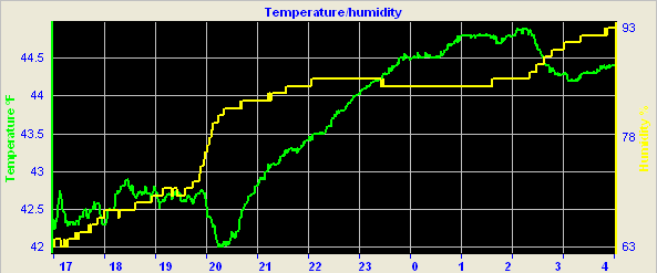
| Current Weather | Dry | Current Temperature | 68.5 °F (20.3°C) (Heat Index 74.8 °F ), Apparent temp 69.6 °F |
| Maximum Temperature (since midnight) | 70.6 °F at: 0:00 AM | Minimum Temperature (since midnight) | 59.8 °F at: 6:30 AM |
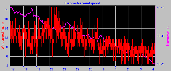
| Average windspeed (ten minute) | 4.1 mph | Wind Direction (ten minute) | NNE (20ş) |
| Heat Index | 74.8 °F | Maximum Gust (last hour) | 10.0 mph at: 7:55 AM |
| Maximum Gust (since midnight) | 10.0 mph at: 7:55 AM | Maximum 1 minute average (since midnight) | 7.9 mph at: 7:35 AM |
| Rainfall (last hour) | 0.00 in. (0.0 mm) | Rainfall (since midnight) | 0.00 in. (0.0 mm) --- |
| Rainfall This month | 4.46 in. (113.3 mm) | Rainfall To date this year | 18.02 in. (457.7 mm) |
| Maximum rain per minute (last hour) | 0.00 in/min | Maximum rain per hour (last 6 hours) | 0.00 in/hour |
| Yesterdays rainfall | 0.00 in | DewPoint | 56.7 °F (Wet Bulb :61.6 °F ) |
| Humidity | 66 %, Humidex 74.3 °F | Barometer corrected to msl | 30.006 in. (1016.1 hPa) |
| Pressure change | +0.01 in. (last hour) | Trend | STEADY |
| Pressure change (last 12 hours) | +0.14 in | Pressure change (last 6 hours) | +0.08 in |
| Current Indoor temp. 77.6 °F | |||
| Current Indoor hum. 41 % | |||


Expires:202607202000;;272434
FPUS51 KOKX 200610
ZFPOKX

Zone Forecast Product
National Weather Service New York NY
209 AM EDT Mon Jul 20 2026


NYZ179-202000-
Southern Nassau-
209 AM EDT Mon Jul 20 2026

.TODAY...Sunny. Highs in the upper 70s. Northeast winds around
5 mph, becoming south this afternoon.
.TONIGHT...Clear in the evening, then becoming mostly cloudy.
Lows in the upper 60s. South winds 5 to 10 mph. Gusts up to
20 mph after midnight.
.TUESDAY...Partly sunny with a chance of showers in the morning,
then showers likely with a chance of thunderstorms in the
afternoon. Humid with highs in the upper 70s. South winds 10 to
15 mph with gusts up to 25 mph. Chance of rain 60 percent.
.TUESDAY NIGHT...Showers with a chance of thunderstorms in the
evening, then showers with a slight chance of thunderstorms after
midnight. Humid with lows in the lower 70s. Southwest winds 10 to
15 mph with gusts up to 25 mph. Chance of rain 90 percent.
.WEDNESDAY...Partly sunny. Showers likely with a slight chance of
thunderstorms in the morning, then a chance of showers with a
slight chance of thunderstorms in the afternoon. Humid with highs
in the lower 80s. Southwest winds 10 to 15 mph with gusts up to
25 mph. Chance of rain 70 percent.
.WEDNESDAY NIGHT...Partly cloudy with a chance of showers in the
evening, then mostly clear after midnight. Lows in the mid 60s.
Chance of rain 30 percent.
.THURSDAY...Sunny. Highs in the lower 80s.
.THURSDAY NIGHT...Mostly clear. Lows in the mid 60s.
.FRIDAY...Sunny. Highs around 80.
.FRIDAY NIGHT...Partly cloudy. Lows in the upper 60s.
.SATURDAY...Sunny. Highs in the lower 80s.
.SATURDAY NIGHT...Mostly clear. Lows in the upper 60s.
.SUNDAY...Mostly sunny. Highs in the mid 80s.

$$


KENNEDY INTERNATIONAL AIRPORT , NY, United States (KJFK) 40-38N 073-46W 9M
Jul 20, 2026 - 07:51 AM EDT / 2026.07.20 1151 UTC
Wind: from the N (010 degrees) at 8 MPH (7 KT):0
Visibility: 10 mile(s):0
Sky conditions: partly cloudy
Temperature: 69.1 F (20.6 C)
Dew Point: 54.0 F (12.2 C)
Relative Humidity: 58%
Pressure (altimeter): 30.01 in. Hg (1016 hPa)
Pressure tendency: 0.05 inches (1.8 hPa) higher than three hours ago
ob: KJFK 201151Z 01007KT 10SM SCT250 21/12 A3001 RMK AO2 SLP163 T02060122 10206 20172 51018
cycle: 12
Southern State Parkway Traffic Cam
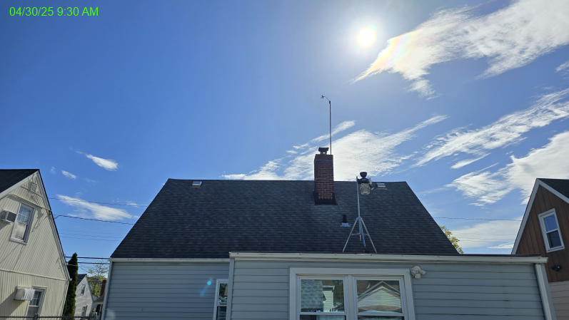
Weather Station Location


Click here for the NOAA report to date for the month


![]()
Use the RELOAD facility on your browser to retrieve the latest data.


Weather station in service since 01/01/2005
Website statistics since 03/05/2025